Logo

ACTION

PLAN

This Action Plan seeks to reduce current and future risks due to flooding and additional climate hazards

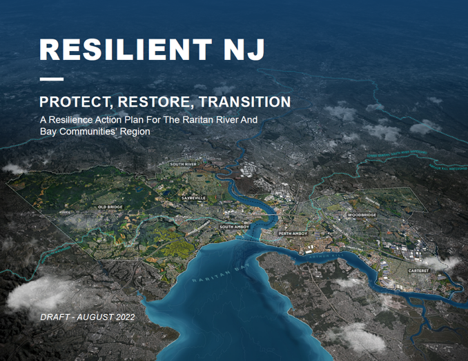
This Action Plan (Español) represents two years of work developing an implementable regional resilience and adaptation action plan that provides a roadmap for addressing current and future flooding for the Raritan River and Bay Region. This Action Plan is the culmination of the three preceding reports, the Visioning Report, About Our Region Report, and Flood Impact Assessment. It provides an actionable roadmap that includes clear next steps for the region to reduce risk and improve quality of life by means of thoughtful and targeted resilience actions.

The project team welcomes your feedback on:

  • The specific resilience actions recommended;
  • The lead entities and next steps identified for each action;
  • And any additional information you feel is needed to make the plan actionable.
i

A ROADMAP TO RESILIENCE

The magnitude of flood risk in the RRBC region today and in the future demands action at multiple scales, shown below. The Implementation Roadmap at the end of the Action Plan lists all actions identified at each scale and includes additional detail about specific recommended locations, lead entities, immediate next steps, partners, and costs.

REGIONAL STRATEGIES

The regional resilience strategies recommended fall under nine strategy types, based on the broad approach:

Policy and Governance

  • Governance and continued coordination
  • Zoning and land use policy

Physical and Nature-Based Infrastructure

  • Adapt or protect critical facilites
  • Resilient mobility systems
  • Stormwater management
  • Coastal resilience
  • Resilient transformation of contaminated sites and brownfields

Outreach, Education, and Capacity Building

  • Flood awareness outreach campaigns
  • Technical support for property owners

    Sub-Watershed

    The sub-watersheds include the following:

    • Arthur Kill Waterfront
    • Woodbridge Creek
    • Raritan Riverfront and Bay
    • South River / Washington Canal
    • Cheesequake / Laurence Harbor
    • Rahway River and Tributaries

        Resilience Opportunity Areas

        Resilience Opportunity Areas include the following:

        • Noe’s Creek (Arthur Kill Waterfront)
        • Heards Brook (Woodbridge Creek)
        • Middlesex County Greenway Extension (Raritan Riverfront and Bay)
        • South River and Sayreville Main Street (South River / Washington Canal)
        • Cheesequake Inlet (Cheesequake / Laurence Harbor)
          Follow the links below to explore different sections of the Action Plan:

          Share your feedback! Click this link or email us at ResilientRRBC@dep.nj.gov

          Resilient NJ Raritan River and Bay Communities Roadmap

          This timeline outlines the program’s process for developing the Action Plan based on community and stakeholder input and technical analyses. Scroll to the left to view links to prior resiliency efforts in the Resilient NJ Raritan River and Bay Communities, which helped create the foundation for the current initiative, and a look at the program’s timeline.

          Preloader
            • Regional NJDEP Blue Acres – New Jersey launched the Blue Acres program, within the Green Acres program, to buyout flood-prone properties at pre-Sandy appraisal values. Woodbridge, South River, Sayreville, and Old Bridge participate in the program. Find more information here.
            • Perth Amboy NJDEP Bulkhead Repair and Beach Renourishment – Perth Amboy replenished a half-mile of beach sand, built a perimeter wall adjacent to a roadway, and constructed a new bulkhead. Read the report here.
            • Perth Amboy Waterfront Development and Advisory Committee – Created by the Mayor of Perth Amboy to study and prioritize projects to stabilize, replace, enhance, and restore facilities and infrastructure damaged by Sandy. Projects focused on waterfront repairs and restoration​.
            • South River and Woodbridge Strategic Recovery Planning Reports – Prepared reports through the NJ Dept. of Community Affairs as part the Post-Sandy Planning Assistance Grant Program. The reports summarize vulnerabilities and identify strategies for rebuilding these communities in more resilient ways. Read the reports here and here.
            • Strategies for Flood Risk Reduction for Vulnerable Populations along Arthur Kill (Carteret and Woodbridge) – Report by Rutgers University that assessed the flood vulnerability of communities along the Arthur Kill waterway to advance the development of mitigation measures to address vulnerabilities. Read the report here.
            • Perth Amboy “Getting to Resilience” Recommendations Report – Building on a questionnaire developed by NJDEP, the Jacques Cousteau National Estuarine Research Reserve Effort worked with the Perth Amboy to develop a set of recommendations for reducing vulnerability and increase preparedness by linking planning, mitigation, and adaptation. Read the report here.
            • Middlesex County Hazard Mitigation Plan – This update included re-evaluation of the hazards, identification of recent storms, and updated risk assessment, mitigation goals, strategies, and mitigation priorities. Read the plan here.
            • Woodbridge Sustainable Community Plan and Climate Action Plan – This plan by the Township provides long-term goals for greenhouse gas emissions reductions and detailed descriptions of actions for achieving those goals. Read the plan here.
            • South Amboy Master Plan – This master plan by the City of South Amboy includes a Sustainability Element that provides recommendations for reducing greenhouse gas emissions, renewable energy, green building and design, land use and mobility, and water. Read the plan here.
            • Perth Amboy Raritan River Bridge Replacement – Replacement of existing swing bridge which carries NJ Transit’s NJCL trains over Raritan River. The existing 1908 bridge was damaged during Sandy. Read more here.
            • Old Bridge Coastal Vulnerability Assessment and Getting to Resilience – This report was prepared by Rutgers University for the Township to assess community vulnerability to sea level rise projected for the year 2050 along with a Category One coastal storm surge. Read more here.
            • Regional Restoration of the Edison Pump Station – Perimeter floodwall around Edison Pump Station, located in Woodbridge, at 23 ft elevation to protect from 500-year flood event. The pump station pumps sanitary sewage from Carteret, Perth Amboy, Edison, and Woodbridge to the Central Treatment Plant in Sayreville. Funding was from FEMA Public Assistance Program. Read a summary of the plan here.
            • Woodbridge Floodplain Management Plan – This plan was developed by the township of Woodbridge to help increase flood risk outreach education, floodplain restoration, and sound record- keeping. Read the plan here.
            • Woodbridge Roots for Rivers – The Township of Woodbridge was awarded a grant for stream bank stabilization, native plantings, and flood management along Camel Creek, with the goal of increasing ecosystem services provided by the open space corridor within the project area. Access the plan here.
          • VISION AND PRIORITIES

            What do we want our region to look like in 2070? What should stay the same and what should change? What do we want our relationship with water to look like?

          • RISKS AND TOOLS

            What neighborhoods and infrastructure in our region are most at risk of flooding today and in the future (2070)? What tools do we have to address these risks?

          • POTENTIAL SOLUTIONS

            What policies, programs, or projects can be implemented to address risks and achieve the identified visions? How will the solutions impact our region?

          • ACTION​ PLAN

            What actions do we commit to? What is needed to accomplish these actions? How can each person in our region do something to help?

          • ACTION PLAN IMPLEMENTATION BEGINS

            The region team is working to implement the recommendations of the Action Plan. Through March 2025, the team is focused on identified priority actions.

          Get Involved

          Your input and involvement are critical to increasing the resilience of our communities. Opportunities to engage with the program will be updated periodically on the Get Involved page.


          GET RESILIENT NJ PROJECT UPDATES!

          You can easily stay in the loop with program progress by signing up for periodic email updates via this form.

          EXPLORE OUR RESOURCE LIBRARY

          The Resource Library contains our project reports, engagement materials, and other information about progress.

          The Region Team

          Logo Arcadis
          Carteret Borough Seal
          Logo Scape
          Logo One
          Logo Heyer, Gruel & Associates
          Logo Heyer, Gruel & Associates
          Logo Heyer, Gruel & Associates
          Logo Irys
          YMCA
          Facebook
          Twitter